![](/images/other/stat-length.png)
![Randonnée Marche La Martre - La Martre l'Artuby 04.05.16 - Photo](https://media.geolcdn.com/t/1900/400/ext.pjpeg?maxdim=2&url=https%3A%2F%2Fstatic1.geolcdn.com%2Fsiteimages%2Fupload%2Ffiles%2F1553511878bg_sport_marche.png)
La Martre l'Artuby 04.05.16
Sugg
Utilisateur
![Longueur](/images/other/stat-length.png)
![Altitude max](https://static1.geolcdn.com/siteimages/upload/files/1508320355ic_sort_altitude_max_24dp.png)
![Dénivelé positif](https://static1.geolcdn.com/siteimages/upload/files/1508320355ic_sort_den_pos_24dp.png)
![Km-Effort](/images/other/stat-length.png)
![Altitude min](https://static1.geolcdn.com/siteimages/upload/files/1508320355ic_sort_altitude_min_24dp.png)
![Dénivelé négatif](https://static1.geolcdn.com/siteimages/upload/files/1508320355ic_sort_den_neg_24dp.png)
![Boucle](https://static1.geolcdn.com/siteimages/upload/files/16400158638029165_repeat_loop_refresh_sync_direction_icon.png)
![Marche](https://static1.geolcdn.com/sitytour/trail-icons/101.png)
5h42
Difficulté : Moyen
![Scannez ce code QR pour ouvrir la randonnée dans l'application SityTrail](https://capi.geolives.com/qq0zvz2zws4bq2lad0pu/sitytour/trails/564764/qr.png?size=200)
Application GPS de randonnée GRATUITE
À propos
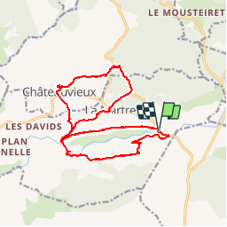
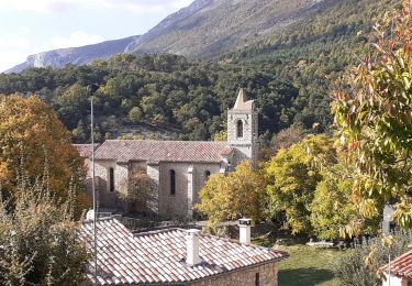
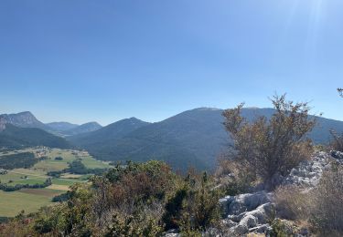
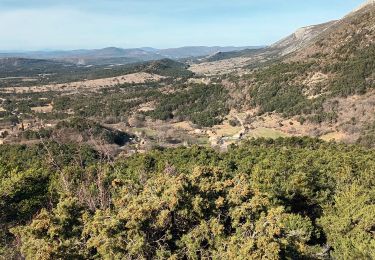
Randonnée Marche de 19,6 km à découvrir à Provence-Alpes-Côte d'Azur, Var, La Martre. Cette randonnée est proposée par Sugg.
Description
Rando RF
Guide : Fernand au départ de la zone picnic en 1006.
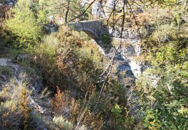
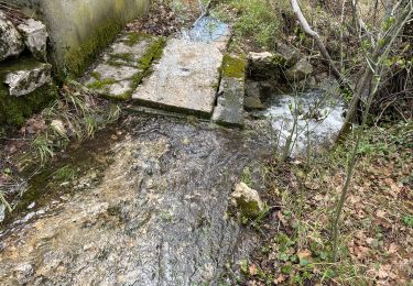
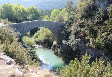
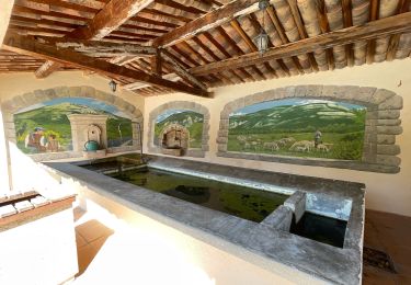
Direction La Martre par le chemin des fours à chaux, puis la boucle Nord pour revenir à Châteauvieux, puis Pont de Madame, vallon des Combes, et Pont des Passadoires.
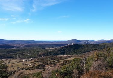
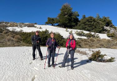
Belle journée ensoleillée, très beaux points de vue.
Localisation
Commentaires
Randonnées à proximité
![Randonnée Marche Bargème - Montagne de Brouis. Bargeme - Photo](https://media.geolcdn.com/t/375/260/12ed21c8-92a7-48a8-a5a0-b4198ffe950d.jpg&format=jpg&maxdim=2)
![Marche Marche](https://static1.geolcdn.com/sitytour/trail-icons/101.png)
Marche
![](/images/other/stat-length.png)
![](https://static1.geolcdn.com/siteimages/upload/files/16400158638029165_repeat_loop_refresh_sync_direction_icon.png)
![Randonnée Marche Bargème - bargeme pierre - Photo](https://media.geolcdn.com/t/375/260/12a20404-1c8f-4d32-b367-b86448c5a645.jpg&format=jpg&maxdim=2)
![Marche Marche](https://static1.geolcdn.com/sitytour/trail-icons/101.png)
Marche
![](/images/other/stat-length.png)
![](https://static1.geolcdn.com/siteimages/upload/files/16400158638029165_repeat_loop_refresh_sync_direction_icon.png)
![Randonnée Marche La Bastide - Lachens le tour trace réelle - Photo](https://media.geolcdn.com/t/375/260/2bcc9855-0aa8-43b5-8275-4dbc1ebfe660.jpg&format=jpg&maxdim=2)
![Marche Marche](https://static1.geolcdn.com/sitytour/trail-icons/101.png)
Marche
![](/images/other/stat-length.png)
![](https://static1.geolcdn.com/siteimages/upload/files/16400158638029165_repeat_loop_refresh_sync_direction_icon.png)
![Randonnée Marche La Bastide - Mont Lachens depuis La Bastide - Photo](https://media.geolcdn.com/t/375/260/56f0544f-2b76-496c-a00e-0afd7a0a58b8.jpg&format=jpg&maxdim=2)
![Marche Marche](https://static1.geolcdn.com/sitytour/trail-icons/101.png)
Marche
![](/images/other/stat-length.png)
![](https://static1.geolcdn.com/siteimages/upload/files/16400158638029165_repeat_loop_refresh_sync_direction_icon.png)
![Randonnée Marche La Bastide - Le Lachens 2024 - Photo](https://media.geolcdn.com/t/375/260/913959e8-b638-421e-a577-0b933e0f73a7.jpg&format=jpg&maxdim=2)
![Marche Marche](https://static1.geolcdn.com/sitytour/trail-icons/101.png)
Marche
![](/images/other/stat-length.png)
![](https://static1.geolcdn.com/siteimages/upload/files/16400158638029165_repeat_loop_refresh_sync_direction_icon.png)
![Marche Marche](https://static1.geolcdn.com/sitytour/trail-icons/101.png)
Marche
![](/images/other/stat-length.png)
![](https://static1.geolcdn.com/siteimages/upload/files/16400158638029165_repeat_loop_refresh_sync_direction_icon.png)
![Randonnée Marche Bargème - Bargème ; Tour du Brouis - Photo](https://media.geolcdn.com/t/375/260/bdd4129f-db89-4282-b7d9-c24fd3a1e82a.jpg&format=jpg&maxdim=2)
![Marche Marche](https://static1.geolcdn.com/sitytour/trail-icons/101.png)
Marche
![](/images/other/stat-length.png)
![](https://static1.geolcdn.com/siteimages/upload/files/16400158638029165_repeat_loop_refresh_sync_direction_icon.png)
![Randonnée sport Bargème - Bargeme pont de madame brouis la bastide - Photo](https://media.geolcdn.com/t/375/260/24bf6eb2-8c8d-4ef9-bab8-4ca50644e049.jpg&format=jpg&maxdim=2)
sport
![](/images/other/stat-length.png)
![](https://static1.geolcdn.com/siteimages/upload/files/16400158638029165_repeat_loop_refresh_sync_direction_icon.png)
![Randonnée Marche La Bastide - Le Lachens-la Bastide-20-03-23 - Photo](https://media.geolcdn.com/t/375/260/0ef2ca21-f587-4552-959d-c511cb58eebf.jpg&format=jpg&maxdim=2)
![Marche Marche](https://static1.geolcdn.com/sitytour/trail-icons/101.png)
Marche
![](/images/other/stat-length.png)
![](https://static1.geolcdn.com/siteimages/upload/files/16400158638029165_repeat_loop_refresh_sync_direction_icon.png)